PICTURE ABOVE: TEMPERATURE OF WATER
The image above shows the temperature of the ocean water at the surface. Measurements were taken from August 6-11, 2001. The temperature scale is in Celsius. Cold temperatures are shown in pink to purple, moderate temperatures in aqua to green and warm temperatures in yellow to red.
This particular data set was taken by the NOAA-16 satellite. NOAA-16 is part of the TIROS series of polar-orbiting, environmental satellites.
Courtesy of NOAA
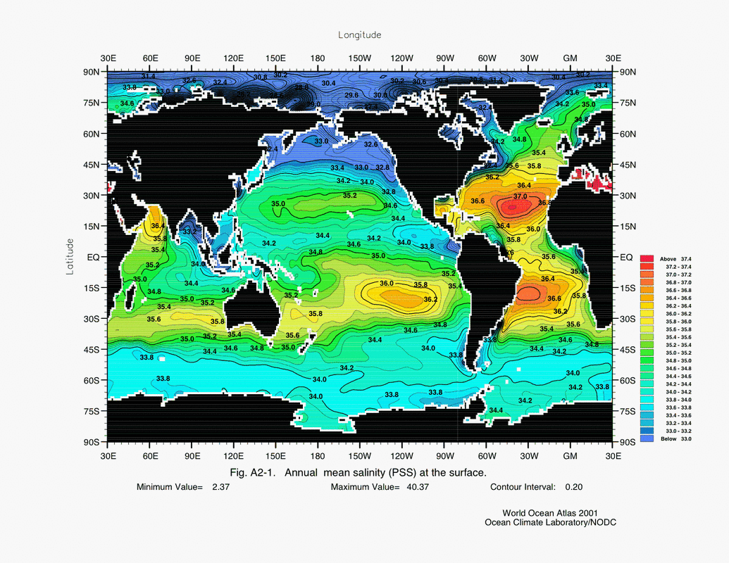
PICTURE ABOVE: SALINITY OF WATER
This image above shows the mean surface salinity of the world oceans. Source: http://serc.carleton.edu/eslabs/corals/4c.html
This image above shows the mean surface salinity of the world oceans. Source: http://serc.carleton.edu/eslabs/corals/4c.html
TASK 1:
Why does surface water sink in the North Atlantic? Let's calculate the density differences between surface waters in the tropics vs. where deep water forms in the north.
1) Look at the first picture above. What is the temperature of the ocean off the coast of Florida? Ireland? northern coast of Greenland?
2) What factors do you think impact the difference in temperatures in these different locations? (in other words, why don't all of these places have the same temperatures) Read this for help: http://www.windows2universe.org/earth/Water/temp.html
3) Look at the second picture above. What is the salinity of the ocean off the coast of Florida? Ireland? northern coast of Greenland?
4) What factors do you think impact the difference in salinity in these different locations? (in other words, why don't all of these places have the same amounts of salinity). Read this for help: http://www.bigelow.org/shipmates/salinity.html
5) Calculate the density of the water mass off the coast of Florida, then of the water mass off the coast of Ireland, and lastly, the water mass of the northern coast of Greenland. You can use this web site for the density calculation. Use the temperatures you reported in #1 and the salinity you reported in #3.
6) Which water mass is less dense (Florida, Ireland, Greenland)?
7) Which water mass is most dense (Florida, Ireland, Greenland)?
8) Read this: http://www.windows2universe.org/earth/Water/density.html. What has a greater impact on density - temperature or salinity? Explain.
9) Since ocean water is rarely measured directly, how are water densities normally determined in the ocean?
10) Ocean Currents: An ocean current is any continuous, directed movement of ocean water that flows in one of the Earth's oceans. Deep-ocean currents are driven by temperature and salinity. The Thermohaline circulation, also known as the ocean's conveyor belt, refers to the deep ocean current that moves like a conveyor belt around Earth's oceans. Predict how do you think temperature and salinity drive the circulation of ocean currents in the North Atlantic Ocean (from equator to Greenland and back).
On the map of your paper, illustrate how the differing densities cause water to move like a conveyor belt in the North Atlantic Ocean. Consider what happens when warm-salty water meets cold-salty water?
